


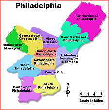
Neighborhoods (see list)
Philadelphia is known as the city of neighborhoods. If you ask ten residents of Philadelphia to name the neighborhoods of the city, you'll probably get ten different answers. There is no definitive list. Some will tell you that there are twelve major neighborhoods. Others will give you a much larger list, some a smaller one.
According to the most recent Census data, Philadelphia is roughly 40% Black in ancestry, about 50% White, and roughly 6% Hispanic. The remainder of the city is Asian, Pacific Islander and Native American in background.
The city itself is highly segregated, with Black neighborhoods dominating many of the older neighborhoods, with the exception of eastern North Philadelphia and parts of South Philadelphia. A narrow band of Hispanic neighborhoods stretches along a corridor on the eastern side of North Philadelphia, separating the areas of Kensington, Port Richmond and Bridesburg from the heart of North Philadelphia.
List of neighborhoods:
Benjamin Franklin Parkway and Fairmount Park
The area on both sides of the Benjamin Franklin Parkway from City Hall to the Philadelphia Art Museum is home to many of the cities museums, such as the Franklin Institute, Museum of Natural History and the Rodin Museum. It is also where you can find the main branch of the Philadelphia Library.
Along with Fairmount Park which stretches along both sides of the Schuylkill River, this area is not often considered a separate neighborhood of Philadelphia, but because of the unique cultural and recreational activities available, we will look at this area separately.
Bridesburg-Kensington-Richmond
Encompassing many of the river wards just north of Center City, this area consists of the areas of the city known as Bridesburg, Fishtown, Juniata Park, New Kensington, North West Kensington, Port Richmond and Richmond.
The area is overwhelming white in terms of race. Homes are predominantly owner-occupied attached units. The area was once predominantly industrial. However, most heavy industry has now left.
Center City
The Center City area of Philadelphia is the area where most suburban residents work, and where most tourists visit. It is home to most of the large businesses in the city.
Center City also contains many of the most historic areas of the city, including Independence National Park, home to Independence Hall and the Liberty Bell. It is also the home to the Pennsylvania Convention Center and most major hotels, as well as the seat of Philadelphia's government, City Hall.
This area consists of such areas as Center City East and West, Chinatown, the Delaware Riverfront, Franklin-Callowhill, Olde City, Rittenhouse Square, Society Hill and Washington Square.
This area of the city is not highly populated. Those who live here are predominantly white and most live in high rise apartment buildings or in expensive townhouses in the Society Hill area.
Chestnut Hill, Germantown, and Mt. Airy
The area east of Fairmount Park in the northwestern part of Philadelphia finds the neighborhoods of Chestnut Hill, Germantown and Mt. Airy.
Each of these three neighborhoods are very distinct in character.
Situated along cobble-stoned Germantown Avenue in the northwestern part of the city, Chestnut Hill is an official Historic District, and home to more than 100 architecturally significant residences, parks and gardens, the Woodmere Art Museum, and the renowned Morris Arboretum. It is also the home to more than 200 boutique shops, art galleries, antique stores, cozy cafes and fine restaurants. Chestnut Hill is the highest point within the city limits of Philadelphia.
The Germantown area of Philadelphia is one of Philadelphia's oldest settlements. It was originally settled by German émigrés attracted to Philadelphia by William Penn's promises of religious tolerance. It is home to many of the city's historic homes. Unfortunately, however, much of the area is now fairly run down.
The Mt. Airy area of northwest Philadelphia, with a population of more than 40,000 people, has gained national distinction for its richly diverse population. A comfortable and welcoming place to live, it is home to people of many racial and ethnic backgrounds, economic levels, occupations, family life-styles and age groups. The greatest concentration of Jewish households in the Northwest is in Mt. Airy. The area boasts a wide range of housing, from apartments to mansions.
Over 100,000 people live in these areas of northwest Philadelphia. Of that total about one-third are white and two-thirds are black.
Manayunk and Roxborough
Nestled along the east bank of the Schuylkill River in northwest Philadelphia are the neighborhoods of Manayunk and Roxborough.
Named for the Lenape Indian word "manaiung" meaning, "where we go to drink", Manayunk developed due to its proximity to the river and the completion of the Manayunk Canal. Manayunk was once home to numerous textile and paper mills and served as a major transportation link to the port of Philadelphia and inland to the farmlands of Pennsylvania.
Named a National Historic District in 1983, Manayunk has over 65 chic boutiques and galleries and about 30 restaurants. It has become a major destination for shopping and dining enthusiasts.
In the days of heavy industry, company executives would live at the top of the famous hills of this area. The workers lived at the bottom of the hill. Roxborough Avenue was the dividing line. Those houses on the uphill side of Roxborough Avenue were said to be in the Roxborough neighborhood. Those houses below the Avenue were said to be in Manayunk.
Though Roxborough Avenue still is a postal division, it is no longer a class divider. The area is predominantly a middle class, white (94%) enclave.
Northeast Philadelphia
The area generally referred to as Northeast Philadelphia consists of two major sections, the Far Northeast and the Near Northeast. Within the Far Northeast are places with names like Bustleton, Byberry, Upper Holmesburg, Pennypack, and Torresdale. The Near Northeast is home to such places as Foxchase, Frankford, Holmesburg Lawndale, Lexington, Mayfair, Oxford Circle, Tacony and Wissinoming.
Over 400,000 people reside in this area of Philadelphia. The population is overwhelming white (92%).
Primarily a residential area with numerous strip malls and shopping centers, Northeast Philadelphia is home to most of what would be considered the "middle-class" residents of the city. It is also home to numerous small businesses as well as several major industrial corporations primarily along the stretch of I-95 which runs through this area of the city.
An expansive area of the city north of Center City and south of Olney-Oak Lane, North Philadelphia consists of numerous places with names like Fairmount, Hunting Park, Ludlow, Nicetown, Northern Liberties, Spring Garden, Strawberry Mansion, Temple University, Tioga and West Kensington.
The area is almost entirely black in composition with several distinct exceptions. There is a heavy Hispanic concentration in eastern North Philadelphia, and heavily white populated areas in the Fairmount-Spring Garden and southern Kensington areas.
While most neighborhoods in Philadelphia are characterized by households with no children present, North Philadelphia contains a variety of all types of households, with non-children households concentrated in the west of Broad neighborhoods, and female-headed households with children appearing in the eastern segment of North Philadelphia, for the most part.
Situated to the north of North Philadelphia, the Olney-Oak Lane section of the city consists of places with familiar names such as Feltonville, Fern Rock, Logan, Melrose Park, Oak Lane, Ogontz, and Olney.
The area is about 65% black, 25% white and 8% Hispanic. Housing consists primarily of attached dwellings. Over 65% of the homes are owner occupied.
South Philadelphia is one of the most expansive neighborhoods of Philadelphia and one that, in reality, is made up of many smaller neighborhoods bearing such names as Grays Ferry, East Oregon, Hawthorne, Marconi Plaza, Packer Park, Passyunk, Pennsport, Point Breeze, Queens Village, Tasker and many more.
The area is most famous for its depiction in Sylvester Stallone's 1976 film Rocky which included numerous scenes filmed on location along the waterfront, in the Italian Market, in the row homes and along the numerous narrow streets and street corners of South Philadelphia.
South Philadelphia is also home to the best cheesesteak shops in the city, the Philadelphia Sports Complex, where all major sports teams play, as well as the former Philadelphia Navy Yard.
Heavily Italian-American in many areas, South Philadelphia is almost 63% white, however, there are heavily black populated communities in areas such as Grays Ferry, Passyunk, Point Breeze and the areas closest to Center City.
The area of the city known as Southwest Philadelphia is one of the more racially diverse areas of the city. With over 80,000 residents, southwest Philadelphia is 36% white and 60% black.
Southwest Philadelphia includes the areas of Bartram, Eastwick, Elmwood Park, Hedgerow, Kingsessing, Penrose Park, Schuylkill and the industrial areas near the Philadelphia airport.
Much of southwest Philadelphia continues to suffer from difficult economic times.
Beginning at the west bank of the Schuylkill River, West Philadelphia is a widely divergent community. In the area closest to Center City lie many of the city's major colleges and universities including Drexel University, the Philadelphia College of Pharmacy and Science and the University of Pennsylvania.
City Avenue serves as the northwestern boundary of West Philadelphia. Here you will find St. Joseph's University as well as major areas of Fairmount Park. The Philadelphia Zoo and Mann Music Center, while in Fairmount Park are also in West Philadelphia.
As outlined in the Philadelphia Planning Commission's Plan for West Philadelphia, "today, 220,000 people, or about 14% of the City's population, live, shop, and in many cases work in West Philadelphia. These residents share many experiences, some of them unique to West Philadelphia: riding the trolleys into Center City, shopping at 52nd Street (West Philly's Main Street), picnicking and playing ball in Fairmount Park, driving between the support columns of the Market-Frankford El, tending neighborhood garden plots, participating in community meetings or school functions, attending the annual May Fair at Clark Park, and keeping up their houses."
As the report further states, "some West Philadelphia neighborhoods suffer the same ills that affect other older urban areas. Over the last several decades there has been a substantial loss of middle class population, widespread poverty, property deterioration and abandonment, main streets that have declined and don't present the best face of the community, deteriorating infrastructure, and too many incidents of crime against people and property that have had devastating impacts in certain neighborhoods."
"These trends, although not pervasive, are persistent and have affected the quality and the perception of life in the larger West Philadelphia community. The trends that contribute to these negative perceptions must be halted and reversed if West Philadelphia is to sustain itself as a viable urban community."
Approximately three-quarters of the population of West Philadelphia is black living in areas with names like Belmont, Carroll Park, Cobbs Creek, Haddington/Dunlap, Mantua and Parkside. There is also a predominantly white, heavily Jewish area in West Philadelphia in the Overbrook and Wynnefield sections of the city.